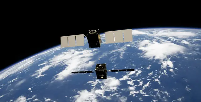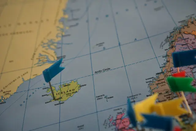



The competition for the Arctic is no longer confined to the ownership of territory, but increasingly concerns the ownership, production, and interpretation of environmental knowledge itself.
About the Article
How does the use of technological monitoring in the Arctic turn environmental information into a security issue? This article will explore how the environment is transforming a new reality in the Arctic by creating the realm of “environmental security”. It argues that the environmental background of the Arctic must be analysed to understand the rise of new technologies and the implications this has for international law, moving environmental governance from cooperation to state surveillance.
Introduction
The Arctic stands at the forefront of the climate crisis, experiencing rising temperatures nearly four times more than the global average, while remaining one of the most extreme regions on earth (Szkarłat, 2025). Once a landscape dominated by climate research stations that served as critical sites for scientific observations, it has now become an arena where great power competitions override scientific cooperation (Szkarłat, 2025). As a result, advances in environmental knowledge of the region have become a tool for states to advance their geopolitical interests, resulting in a shift in how the Arctic is perceived (Luszczuk et al., 2025).
This paper will refer to this process as the “securitisation of environmental science”, a term that couples current climate pressures with security, revealing how such geographies are transforming ideas surrounding national sovereignty in the age of the Anthropocene (Luszczuk et al., 2025; van Dulst, 2023). It is important to note, however, that while “environmental security” is often understood from a humanitarian perspective as the dangers posed by environmental pressures on infrastructures, communities, and conflict, this paper instead adopts the term “security” through the lens of power competition (van Dulst, 2023). Such “securitisation” takes many forms, but is largely characterised by the usage of environmental data—from satellite monitoring, 3D mapping, glacier monitoring, and other climate assessment indicators—as a means to further geopolitical interests, expand military operations, and secure the extraction of the Arctic’s resources for political gain.
This article will begin by providing a background of the UNCLOS agreement, which served as a turning point in current geopolitics of the Arctic region, namely the focus on territorial competitions. It will then analyse how technologies, specifically satellites and land-based monitoring, have enabled geopolitical competition to persist and change. Thus, what it aims to show is that understanding the current environmental background of the Arctic reveals how geographies are inseparable from the social and political character of the region, providing a new dimension to security studies by focusing on how the environment influences, and is influenced by, state power.
UNCLOS and a Background on the Geopolitics of the Arctic Region
The Arctic region emerged as a major international geopolitical arena following the Cold War (van Dulst, 2023). It was during this period that conflicting powers who occupied the region, primarily the US and Russia, began to rely on the Arctic to boost military presence, perceiving it as a valuable bridge for the transportation of missiles, nuclear submarines, and aviation routes (van Dulst, 2023). However, it was also during the Cold War that the term “Arctic Exceptionalism,” gained traction, depicting the Arctic as a zone of peace and cooperation despite ongoing tensions (Luszczuk et al., 2025). Nevertheless, Nation States’ growing reliance on the Arctic for strategic efforts revealed discrepancies.
On the international scale, the 1982 United Nations Convention on the Law of the Sea (UNCLOS) was created as a key instrument for governing marine disputes and regulating activities in international waters (Petkunaite, 2025). Prior to this law, there was no comprehensive, single international treaty governing the Arctic Ocean. Following Russia’s symbolic flag planting on the Arctic seabed to exert its influence in 2007, five of the Arctic’s coastal states—Canada, Denmark (Greenland), Norway, the United States, and Russia—became increasingly reliant on UNCLOS as a key aspect of their strategy, further turning the Arctic into a temporary “zone of cooperation” under UN maritime law (Petkunaite, 2025). Thus, Arctic nations collectively affirmed that UNCLOS is the definitive legal framework for the region in May 2008 (Petkunaite, 2025).
As an instrument of international law, UNCLOS functions essentially as the “constitution for the oceans,” formalising customary maritime practices into a legally binding framework (Karim et al., 2024). However, international law relies heavily on the universal compliance and ratification of global powers to maintain total efficacy (Karim et al., 2024). Despite participating heavily in the initial drafting of the treaty between 1973 and 1982, the United States remains the only major Arctic coastal nation that has not ratified UNCLOS (Karim et al., 2024; Petkunaite, 2025). This was largely due to concerns over national sovereignty and deep-sea mining laws, as UNCLOS aimed to define the international seabed as a shared global resource (Watson, 2016). As a result, Washington rejected it because it mandated technology and profit-sharing with developing nations. Because the US remains outside the treaty, it lacks the legal standing to have its Arctic continental shelf claims officially certified by the UN, forcing Washington to protect its regional interests through unilateral high-tech surveillance (Petkunaite, 2025; Watson, 2016).
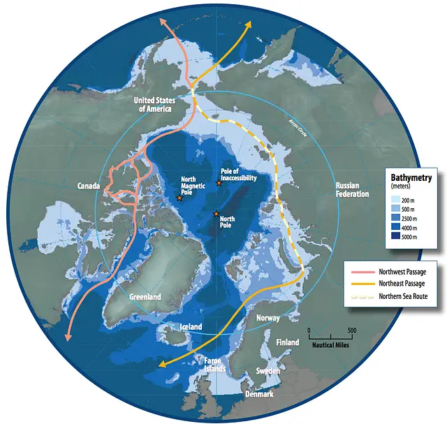
Credit: Map adapted from the Arctic Council’s Arctic Marine Shipping Assessment (AMSA) 2009 Report via Wiki Commons depicting the Northeast Passage, the Northern Sea Route and Northwest Passage, and bathymetry.
Natural Resource Geopolitics
When the Arctic faced a significant period of ice melting in the 2000s, it only exposed the region’s underlying competition. Because of a process known as “Arctic Amplification,” Arctic sea ice warms nearly four times faster than other regions, opening up new navigational corridors (van Dulst, 2023; Cemal Kakışım, 2025). While the Arctic during the Cold War was deemed geographically crucial due to its military transit locations, the melting of sea ice now makes its rich physical resources— such as rare earth minerals (REEs), oil and natural gas deposits, and other critical minerals— accessible (Cemal Kakışım, 2025). Critical minerals essentially run the modern world by driving everything from advanced computing to electric vehicles (EVs) and defense systems. As a result, sovereignty over Arctic resources is a matter of strict national security rather than solely of strategic advantage. Knowledge of bathymetric data, sonar mapping, and geology has become imperative (Cemal Kakışım, 2025).
While the original UNCLOS treaty was negotiated between 1973 and 1982 as a global maritime treaty, rather than one specific to the Arctic, it has nonetheless been extended to influence sovereignty claims, resource rights, and jurisdiction in the region (United Nations, 2012). UNCLOS consists of 320 articles and nine annexes, which outline a series of rules for territorial seas including exclusive economic zones (EEZs), marine environmental obligations, and navigation rights (United Nations, 2012). Article 76, for example, states that if a country can scientifically prove that its geological continuity extends beyond its 200-mile continental shelf, it can claim ownership of that extended seabed (Oceans & Law of the Sea United Nations, n.d.). The significance of Article 76 extends far beyond traditional maritime law. By establishing geological continuity as the benchmark for sovereign extension, UNCLOS effectively transformed environmental science into legal evidence. Consequently, scientific data became highly politicised, incentivising states to invest heavily in sophisticated technologies to produce the empirical data required to justify their territorial ambitions (Watson, 2016).
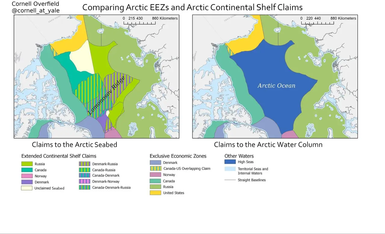
Credit: Comparing Arctic EEZs and Continental Shelf Claims. Map created by Cornell Overfield via Wiki Commons. The left panel illustrates contested claims to the continental shelf and seabed, highlighting where Russia, Canada, and Denmark overlap along the Lomonosov Ridge. Conversely, the right panel displays claims to the water column, showing the uncontested high seas at the center of the Arctic Ocean.
This intersection of sovereignty, territory, and environmental security remains highly volatile. For instance, recent US political interest in acquiring Greenland exemplifies serious modern concerns over territorial sovereignty and the military expansion of major powers (van Dulst, 2023). In response to growing regional competition, Denmark has invested two billion USD in strengthening its military and radar presence in the Arctic (van Dulst, 2023). While the US remains largely focused on national security interests, other global powers such as China and Russia are aggressively pursuing the Arctic’s critical mineral deposits and expanding their technological surveillance infrastructure to secure them. Furthermore, in 2014, President Xi Jinping stated that China has aspirations to become a polar great power and establish a “Polar Silk Road” for securing rich natural resources (Trym Eiterjord, 2023).
The Arctic’s Technological Paradigm Shift: Satellites and Other Monitoring Technologies
The gradual securitisation of environmental science can also be understood as a process of “epistemic territorialisation.” In this way, the Arctic’s unique environment does not make it an inherently political region. Rather, it became political through the way it was used and perceived, ultimately transforming how its physical space was controlled and contested. As argued by Bruun & Steinberg (2018, p. 148), increased “research into a place’s physical geography is inherently territorialising.” Thus, the reason for such change can be understood through how knowledge of the Arctic has been acquired, understood, and used (Trym Eiterjord, 2023).
This epistemic territorialisation evolved due to the rise of advanced technological surveillance systems such as satellite imagery, underwater listening devices, and radars following the Cold War. It was through technology that powers aimed “to recruit the Earth itself as an informant” (Chambliss, 2020, p. 67). Since the Cold War, however, the demand for investment into Arctic monitoring has only been on the rise, expanding beyond border security to surveillance of the entire region (Trym Eiterjord, 2023).
In 2019, China launched its polar remote sensing satellite, the “Ice Pathfinder,” to track sea ice mechanics and atmospheric dynamics. This launch marked the beginning of a planned 24-satellite polar network designed to eliminate China’s dependence on foreign imagery, especially as Western satellites approach the end of their service lives (Trym Eiterjord, 2023; Zhang et al., 2021). While officially framed as a peaceful contribution to climate research, these advanced radar and tracking assets provide critical dual-use capabilities for state surveillance. This ambiguity extends to the water as well, where China’s commissioning of the advanced, sensor-heavy Xue Long 2 icebreaker has vastly increased its independent mapping mobility (Trym Eiterjord, 2023). Reports from the Canadian Global Affairs Institute question whether these polar vessels act as “trojan dragons” under the guise of science to fuel Beijing’s geopolitical ambitions to control and secure its “Polar Silk Road” (Falco et al., 2024; Trym Eiterjord, 2023).
In response to rising threats, the EU launched its Arctic Observatory for Copernicus SEA Service Project (ARCOS) in December 2020. Functioning as an automated intelligence framework under the broader umbrella of the European Union’s Copernicus Earth observation network, ARCOS uses Artificial Intelligence to merge large datasets collected from space-based platforms like the Sentinel-1 and Sentinel-2 satellites (CORDIS, 2025). The goals of ARCOS are both security and environmental-based, often merging between the two. For example, the aim was to track illegal oil spills, marine hazards, and other environmental threats to conserve the Arctic’s unique environment, while also receiving vital data regarding sea ice melting, pollution, and sea ice coverage (ARCOS Project EU, 2026). Simultaneously, it also sought to identify where natural resources are located, identify foreign objects, and map the operational status of critical coastal facilities. In response, the EU can then deploy both the Sentinel-1 and Sentinel-2 satellites, paired with machine learning models to work towards total regional awareness (CORDIS, 2025).
On-the-ground mechanisms have also been established. Because melting sea ice has further exposed greater navigational corridors, this has welcomed an increase of “under the radar” ghost ship fleets. By international maritime law, all large commercial vessels are required to broadcast their position using a tracking system known as the Automatic Identification System (AIS) (Heiselberg et al., 2022). However, an increasing number of ships navigating polar waters deliberately turn off their transponders or fake their GPS coordinates to hide their movements (Heiselberg et al., 2022). In the Arctic, these dark fleets often work to smuggle oil, bypass international sanctions, or engage in unauthorised resource extraction (Heiselberg et al., 2022) As a result, governments are forced into a continuous technological arms race, where they must build advanced sensors to identify threats on multiple levels—air, ground, and sea— by using a series of advanced technologies (Braw, 2026; Heiselberg et al., 2022; Chambliss, 2020). Thus, the competition for the Arctic is no longer confined to the ownership of territory, but increasingly concerns the ownership, production, and interpretation of environmental knowledge itself.
Conclusion
The case of the Arctic reveals how scientific cooperation has been turned into a geostrategic arena. Furthermore, it raises critical future implications regarding growing reliance on satellites, AI, and other data-driven technologies for gathering information, executing strategic plans, and achieving geopolitical ambitions. In areas where the concept of the “global commons”—such as space, the deep sea, and the Arctic—remains legally vague, and where states are constantly turning toward AI technologies, the question is no longer just about who holds advanced technology, but what implications these technologies bring.
As environmental science becomes increasingly inseparable from state surveillance and strategic interests in the Arctic, new governance frameworks must be established to regulate data sovereignty, transparency, and verification. Furthermore, the environmental dimension of security should occupy a more central place within contemporary security studies to better understand how changing landscapes, such as the Arctic, both influence and are influenced by geopolitical ambitions. Thus, understanding the physical environment of the Arctic is no longer just a matter of climate science, but an essential lens for understanding the evolution of state power and sovereignty.
References
Braw, E. (2026, April 22). The shadow fleet is undermining the maritime order more brazenly than ever. Atlantic Council https://www.atlanticcouncil.org/in-depth-research-reports/the-shadow-fleet-is-undermining-the-maritime-order-more-brazenly-than-ever/
Bruun, J., & Steinberg, P. (2018). Placing territory on Ice: Militarisation, measurement and murder in the high Arctic. In K. Peters, P. Steinberg, & E. Stratford (Eds.), Territory beyond terra. https://doi.org/10.1017/CBO9781107415324.004
Cemal Kakışım. (2025). The Arctic is Warming: Green Transition, Critical Minerals and Energy Sources, New Maritime Routes and Geopolitical Competition. Gümüşhane Üniversitesi Sosyal Bilimler Dergisi, 16(3), 1171–1186. https://doi.org/10.36362/gumus.1638450
CORDIS, cordis.europa.eu. (2025, January 28). Arctic Observatory for Copernicus SEA Service. CORDIS | European Commission. https://cordis.europa.eu/project/id/101004372
Chambliss, W. (2020). Spoofing: The Geophysics of Not Being Governed. In Voluminous States: Sovereignty, Materiality, and the Territorial Imagination.
Falco, G., Boschetti, N., & Nikas, I. (2024). Undercover Infrastructure Dual-Use Arctic Satellite Ground Stations. CIGI Papers, 291. https://www.cigionline.org/static/documents/no.291_HM8ToWL.pdf
Heiselberg, P., Sørensen, K. A., Heiselberg, H., & Andersen, O. B. (2022). SAR Ship–Iceberg Discrimination in Arctic Conditions Using Deep Learning. Remote Sensing, 14(9), 2236. https://doi.org/10.3390/rs14092236
Karim, R., Hamid, S. A., & Mohd, H. (2024). Maritime dispute resolution: understanding adequacy of UNCLOS: a systematic review. Australian Journal of Maritime & Ocean Affairs, 1–22. https://doi.org/10.1080/18366503.2024.2416334
Oceans & Law of the Sea United Nations. (n.d.). PREAMBLE TO THE UNITED NATIONS CONVENTION ON THE LAW OF THE SEA. Www.un.org. Retrieved March 1, 2020, from https://www.un.org/Depts/los/convention_agreements/texts/unclos/part6.htm
Petkunaite, D. (2025). CUNY Academic Works CUNY Academic Works Cooperation or Conflict in the Arctic? UNCLOS and the Barents Cooperation or Conflict in the Arctic? UNCLOS and the Barents and Beaufort Sea Disputes and Beaufort Sea Disputes. https://academicworks.cuny.edu/cgi/viewcontent.cgi?article=1049&context=cc_etds_theses
Project EU, A. (2026). ARCOS (Arctic Observatory for Copernicus SEA). Arcos-Project.eu. https://arcos-project.eu/dashboard
Szkarłat, M. (2025). Securitization of scientific cooperation: The case of the Arctic. Polish Polar Research, 5–5. https://doi.org/10.24425/ppr.2025.153919
Trym Eiterjord. (2023). Securitise the volume: epistemic territorialisation and the geopolitics of China’s Arctic research. Territory, Politics, Governance, 12(1), 93–111. https://doi.org/10.1080/21622671.2023.2179535
United Nations. (2012). Overview – Convention & Related Agreements. Un.org. https://www.un.org/Depts/los/convention_agreements/convention_overview_convention.htm
van Dulst, I. (2023). Securitizing the Arctic: New Environmental Security Realities (Master’s thesis, Radboud University). Radboud Repository. https://theses.ubn.ru.nl/server/api/core/bitstreams/fc1297a5-a711-4ad8-9c57-fa93a0dc0283/content
Watson, M. (2016). An Arctic Treaty: A Solution To The International Dispute Over The Polar Region. Ocean and Coastal Law Journal, 14(2). https://digitalcommons.mainelaw.maine.edu/oclj/vol14/iss2/8/
Zhang, Y., Chi, Z., Hui, F., Li, T., Liu, X., Zhang, B., Cheng, X., & Chen, Z. (2021). Accuracy Evaluation on Geolocation of the Chinese First Polar Microsatellite (Ice Pathfinder) Imagery. Remote Sensing, 13(21), 4278–4278. https://doi.org/10.3390/rs13214278